I’d always heard the claims that Australia’s most significant water reform was built on falsehoods, political agenda and flawed science, but seeing for myself fundamentally changed me.
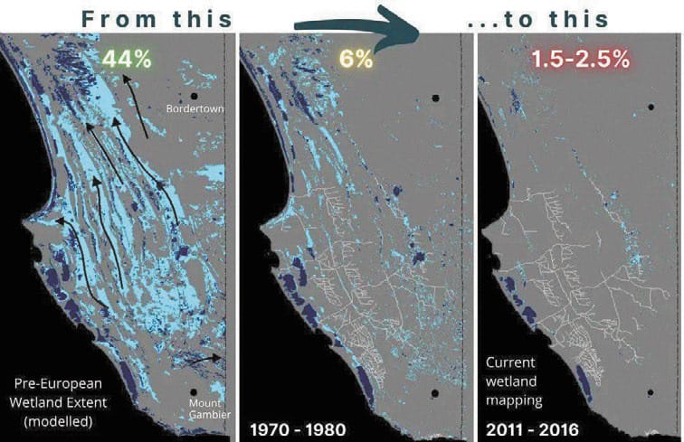
Sitting before me was an estimated 28,000 square kilometres of former wetlands, crisscrossed with, according to the ABC, as reported in 2023, 2,500 kilometres of manmade drains.
I joined a merry band of nine intrepid explorers who ventured to South Australia’s agricultural crown jewel to understand more of the Murray-Darling Myths. With reliable annual rainfall of between 500 and 800mm, and proximity to important ports and trade routes, the region became not only the agricultural crown jewel of South Australia but also the Murray-Darling Basin’s missing link.
Today’s basin-wide Environmental Watering Strategy provides minimum expected outcomes for end-of-basin flows under the 2007 Water Act. These include:
• barrage flows of at least 2000 GL year on a three-year rolling average of 95 per cent of the time and a two-year minimum of 600 GL year;
• water levels in the lower lakes to be above sea-level and at þ0.4 AHD (Australian height datum) 95 per cent of the time; to provide additional flows to the Coorong, and to prevent acidification, acid drainage and riverbank collapse below Lock 1
• further reducing salinity levels in the Coorong and Lower Lakes: the maximum average daily salinity in the Coorong South Lagoon is less than 100 grams per litre; the maximum average daily salinity in the Coorong North Lagoon is less than 50 grams per litre; the average daily salinity in Lake Alexandrina is less than 1000 microsiemens per centimetre for 95 per cent of years and 1500 microsiemens per centimetre all of the time;
• the Murray River mouth to be open 90 per cent of the time without the need for dredging to an average depth of 1 m.
• further increasing flows to the Coorong through the Murray Mouth Barrages, and supporting fish migration
All very noble objectives, but what if I told you that the most significant and reliable supply of freshwater to the Coorong and Lake Albert once came from South Australia itself, an area that is not included as part of the Murray-Darling Basin! Yes, 28,000 square kilometres of what were wetlands prior to European intervention are excluded from the Murray-Darling Basin and the Basin Plan, despite sitting right beside the environmental icons underpinning the end-of-system targets.
With 80 per cent of environmental water recovery coming from the southern connected systems of NSW and Victoria, it appears much easier politically to spend $13 billion killing rural communities and undermining food security than addressing South Australia’s sins of the past.
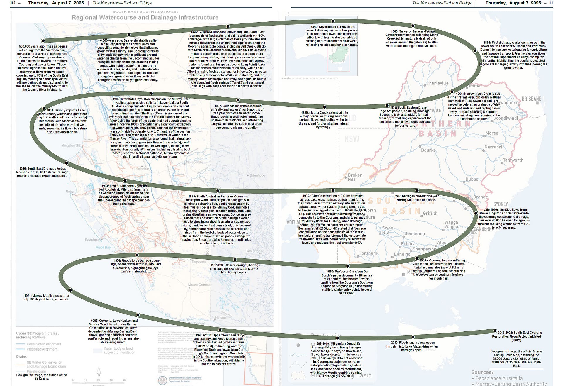
It was a political move of pure genius! As the millennium drought struck, South Australia refused to let the ocean water back into the estuary, providing an environmental disaster that was the perfect springboard to point the blame upstream for all the woes.
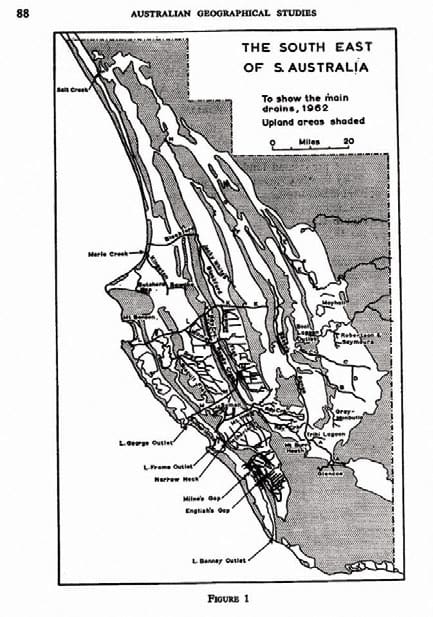
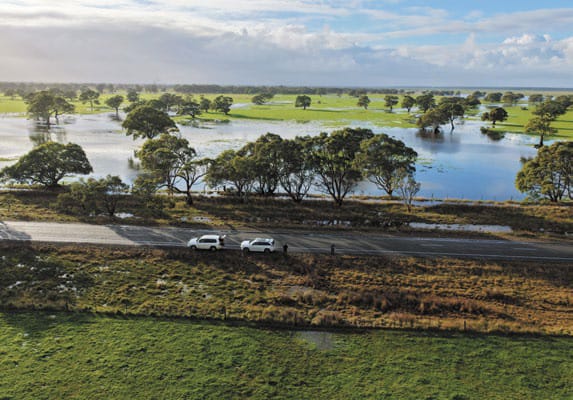
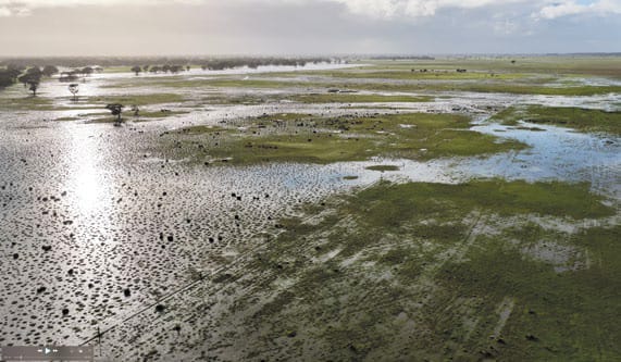
While flows from the Murray are crucial for a healthy system, our tour sought to understand the sheer size and scale of the Basin’s missing catchment. Drains as far up as Penola were noted as we made our way to Millicent. The Millicent Museum held a treasure trove of historical information on the vast drainage network. In 1860, Surveyor General George Goyder recommended extending Maria Creek (which naturally drained only ~3 miles around Kingston SE) to alleviate local flooding around Millicent.
In an historical video presented at the museum and available on YouTube, the following transcripts were taken.
“It was nearly impossible to travel from Adelaide in the winter. Sometimes three-quarters of the whole area was underwater, and to travel the 100 km from Penola to Robe, more than half of the distance was underwater.”
“Mr. John MacDonald, who opened the Kangaroo Inn at Reedy Creek in 1861, claimed that in 1849 he could have sailed a boat from the Murray River to Mount Muirhead near Millicent, and the mail coming from Adelaide via Meningie would take six or more days, with the mailman often having to put the mailbags on the horse’s neck to keep them dry before plunging into the water.”
Before the 1860s, some farmers had constructed small private drains, but it wasn’t until 1863 that a party from Adelaide, consisting of Hanson Milne and the Surveyor General, Mr. George Goyder, saw a great vison of an expansive drain network. Work that started with barrows and shovels, with a workforce peaking at 500 men, and around 1900 trials began with mechanised earthmoving equipment, and work continued for more than a century.
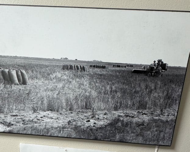
Historical photos depict the once wetlands being drained into productive farmland. While estimates vary on how much of the southeast was swamp, General George Goyder in the 1860s put the figure as high as 50 per cent.
Narrow Neck Drain is dug as the first major public drain. Natural dam wall at Tilley Swamp’s end was removed, accelerating drainage of elevated wetlands and redirecting flows away from the Coorong’s Southern Lagoon, initiating compromise of the unconfined aquifer believed to be present throughout the region.
“Eventually, 300 kilometres of drains were finished, and 50,000 hectares of drain land sold for $7 per hectare, bringing in $350,000 for the government. This set sights on extending drains over larger areas.” Citied the historical drain video.
From Millicent, we tracked the drain down to Southend, where the torrent of freshwater hits the Indian Ocean. The rain on our trip served as an excellent guide in depicting the true wetland nature of this vast region.
It was soon on to Beachport, and the Sutherland Drain ran parallel to our journey before terminating into Drain M. Drain M captures a huge volumes of water, with its origin near Snake Island just outside of Naracoorte.
We made for Robe and stopped at the Woakwine Cutting. In 1957 land holder Murray McCourt wanted to drain the 400 hectares of “useless” flooded peat called Woakwine swamp. The South East drainage board agreed to the idea, but the government would not fund the 28 metres deep cutting required. Murray McCourt, who had experience in construction engineering during the war, and his assistant, Dick McIntyre used a D7 crawler tractor, to remove the 250,000 cubic metres of soil and rock and the eight kilometres of drains required to discharge Woakwine into Lake George.
Passing four lakes, those being George, St Claire, Eliza and Robe, we reached the township of Robe with Drain L greeting us upon our arrival. A night of debriefing over seafood, steak and wine was turned more intimate when our section of the pub lost all lights. With the flickering candlelight being the only source of light, the planned net zero wasn’t looking much fun, yet it provided a cozy ambience.
The morning saw us venture onto Kingston, the big lobster was keeping a watchful eye over Maria Creek, once a humble creek, now an effective drain linking the south east of the area.
It was a constant game of drain spotto as we tracked the coast, just north of Kingston sits the Blackford Drain. The last of the major drains before the start of the Coorong. This huge cutting links the Jecky-White Drain, the Baker Range Drain, the Fair View Drain, the Water Valley Drain and the Reedy Creek, which connects Tilly Swamp Drain, running parallel to the Coorong. It is the Blackford drain that the Upper South East drainage works, started in the 1990s and completed in November 2011, discharged into.
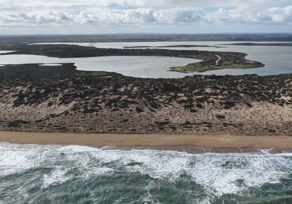
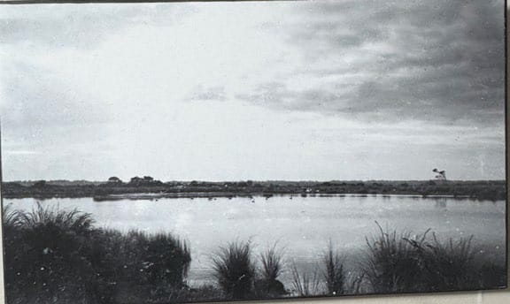
Just up the road is Salt Creek. The creek discharges into the permanent water body of the Southern Lagoon of the Coorong. Tour participant Darren DeBorrteli points out one of the very first things done to facilitate drainage of the lower South East was to remove a natural dam wall at the end of Tilley Swamp in 1864. In 1863, there was so much fresh water entering Tilley swamp that the fresh water ran over this impediment for 5 months. Imagine a massive lagoon at an elevated level just above the Southern Lagoon of the Coorong and running parallel with it all the way back to Kingston and slowly discharging groundwater into it!
Our next stop was Parnka Point, which separates the Southern Lagoon from the Northern Lagoon of the Coorong. The narrow neck of Parnka Point would have played an important role in restricting the very large freshwater flows from the South East unconfined aquifer and may have forced multiple ephemeral openings to the ocean in the Southern Lagoon of the Coorong. Darren DeBortelli points out that this would certainly solve the historical observations of a freshwater-marine interaction. No pre-European diatoms of Murray River plankton have been found beyond the very top of the Coorong near the Murray River, which means the Murray could not be the source of freshwater interaction in the Coorong with ocean water.
It’s hard to fathom blinkers effective enough to shield Australia’s largest water reform from the influence of South Australia’s South East. The vast 28,000 square kilometre catchment sits a stone’s throw from the Murray-Darling Basin, but yet not part of it. Well, part of the problem certainly, just not part of the solution. It’s our communities, food producers, rivers and towns that carry this burden. Where are our state leaders, you ask? I wonder the same thing!
See all the pictures in the issue.
This article appeared in The Koondrook and Barham Bridge Newspaper, 7 August 2025.
