
Charles Sturt University, Media Release, 9 March 2023
A Charles Sturt University academic has led multiple research projects that have produced new artificial intelligence (AI) technologies that will save lives, homes and livelihoods by reducing bushfires.
The research was conducted between 2018 and 2022 and can assist in fire management and reduction, including disaster management for a range of natural disasters and events related to climate change.
Dr Anwaar Ulhaq Senior Lecturer in the Charles Sturt School of Computing, Mathematics and Engineering and Deputy Leader for the Machine Vision and Digital Health Research Group within the Faculty of Business, Justice and Behavioural Sciences, led the research with PhD students.
He said vegetation management is key to controlling some of the natural disasters Australia is facing.
“Bushfires are nothing new in Australia,” Dr Ulhaq said. “However, the 2019-2020 season was unusual in many aspects.
“More than 46 million acres (72,000 square miles) were consumed by the bushfires, which is roughly the size of Syria. During the many fires between September 2019 and March 2020, at least 3,500 homes and thousands of other structures were destroyed and 34 people perished.
“I think vegetation management is key to controlling environmental calamities, especially bushfires that have a huge human, economical, and environmental loss to Australia every year.”
Dr Ulhaq believes that emerging technologies, particularly AI, can be effective combatants against these environmental disasters.
“Controlling radiant heat and ember attacks is critical to protecting lives and property from bushfires,” Dr Ulhaq said.
“Mapping flammable trees such as Cyprus, pines, and eucalyptus in urban and regional suburbs, as well as creating a shelter belt by fire retardant plants such as Acacia cyclops or evergreen plants is one method of reducing radiant heat and stopping embers from blowing onto homes.”
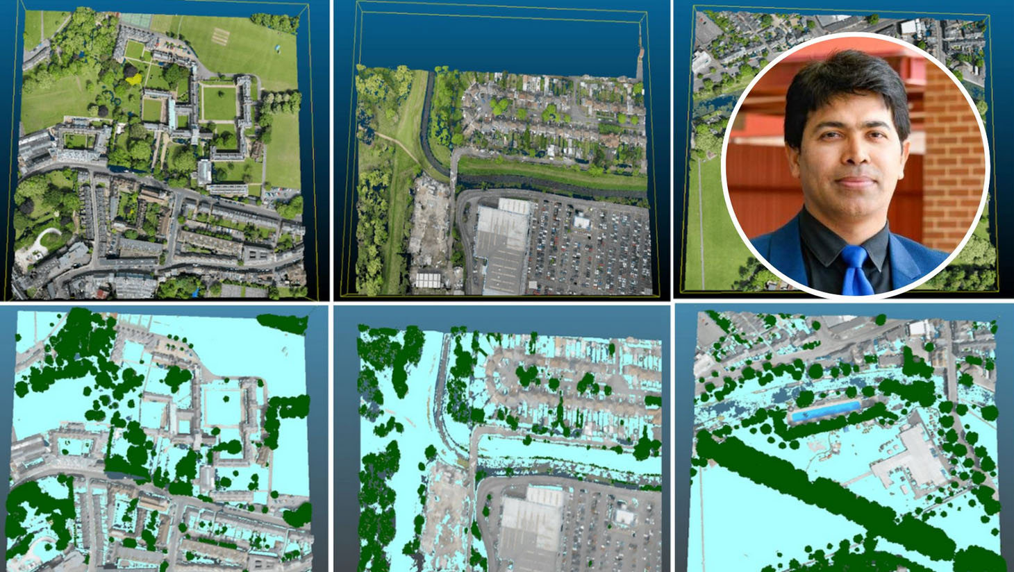
Dr Ulhaq and his PhD student Dr Asim Khan (who graduated in 2022 with a PhD in computer vision) have developed technology that uses computer vision techniques to provide automated detection of these plants and trees, as well as automatic classification and mapping of each species.
“We have developed an automated vegetation detection and mapping system for vegetation management by combining image data from Google Street View (GSV) imagery and manually capturing imagery of street trees in the study area of Wyndham City Council, in Melbourne.
“The technology is powered by data annotation and deep learning,” Dr Ulhaq said.
“The system can assist local governments to improve vegetation management to control the loss of lives and property from bushfires.”
Dr Ulhaq has expanded on this research by using 3D Lidar data to create a virtual and realistic model of vegetation management, which was recently published at an Australian research conference.
A second project Dr Ulhaq has completed, in collaboration with Victoria University, used signal classification and machine learning to detect faults in powerlines caused by vegetation contact.
Dr Ulhaq said that vegetation contact with power lines causes undesired energy flow which is often undetected by overcurrent devices.
“These faults, called low-energy (high-impedance) faults, may go undetected for an arbitrary amount of time and can ignite dangerous fires,” he said.
In response, Dr Ulhaq’s PhD student Dr Douglas Gomes (who graduated in 2021 with a PhD in Signal Processing), developed a machine learning-based feasibility prototype system that has the potential to detect any fault (earthed and between phases) in any type of system (SWER, 3-Phase), which is not attainable with Rapid Earth Fault Current Limiters (REFCL).
“REFCL technology works like a large safety switch – it detects when one line out of a three-phase powerline has fallen to the ground and almost instantly reduces the voltage on the fallen line,” he said.
“At the same time, it boosts the voltage on the two remaining lines in service, which means we can maintain power to homes and businesses while substantially reducing the fire risk.
“The developed prototype system has the potential to be used in conjunction with REFCL to add extra security.”
Dr Ulhaq said that for broader coverage and control, AI is required to be integrated with various data sources and technologies like 3D LiDAR and Digital Twins.
He is currently working on a research project in collaboration with Associate Professor Aamir Cheema from Monash University called Spatial Digital twin for automated insights, which is collecting live and diverse data sources related to Sydney City to monitor live hazards, weather, traffic data, carbon emissions, and air pollution.
This spatial urban digital twin is the first of its kind in the country and has the potential to provide automated live insights for urban planning, climate control, and disaster management.
