New South Wales is facing an increasingly parched winter outlook as latest data reveals a looming expansion of drought conditions across the northeast, southeast, and western regions of the state.
The latest Combined Drought Indicator (CDI) map, released today, paints a sobering picture of the state’s agricultural landscape. While pockets of the far west and southern border regions remain in a “Non-Drought” or “Recovery” status, a significant portion of the inland territory is now classified as “Drought Affected,” with many areas showing signs of intensification.
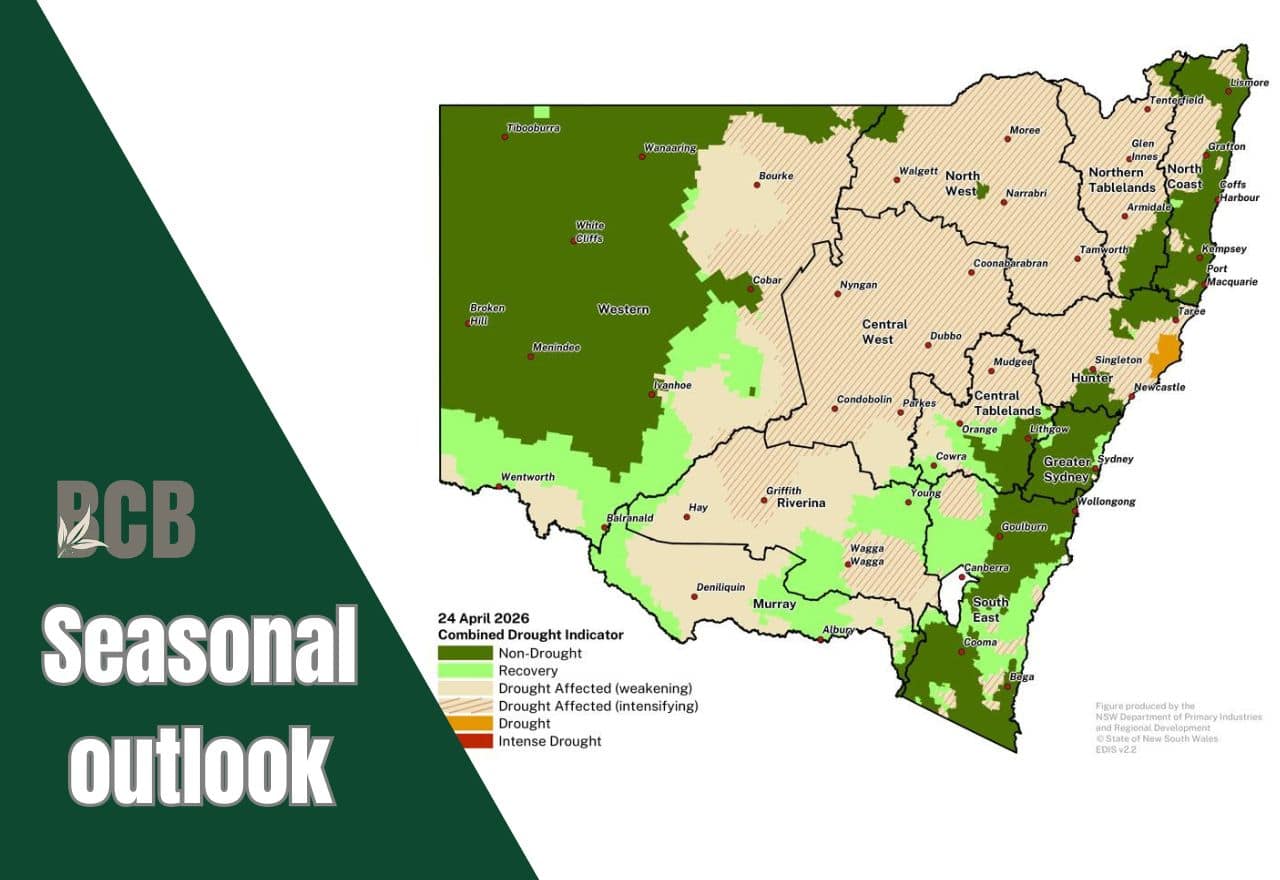
Particularly concerning are the Central West, North West, and Northern Tablelands, which are currently characterised by a “Drought Affected (intensifying)” status. Coastal regions around Newcastle and the Hunter Valley are also seeing “Drought” and “Intense Drought” patches emerge, threatening local primary production as the state transitions out of autumn.
At a glance: The 3-month outlook
- Rainfall: Only a 20-55 per cent chance of exceeding median rainfall through July.
- Temperature: High likelihood of above-median daytime temperatures statewide.
- Forecast confidence: Reliability is currently low due to the time of year; updates are critical.
According to the Bureau of Meteorology’s three-month outlook issued on April 23, the prospects for relief are slim. The probability of above-average rainfall between May and July 2026 remains low for most of the state, ranging from just 20 per cent to 55 per cent. Compounding the lack of moisture, warmer-than-average daytime temperatures are expected to persist, further increasing evaporation rates and stressing livestock and crops.
The Department of Primary Industries and Regional Development (DPIRD) has issued a warning that the geographic footprint of the drought is likely to grow over the next six to eight weeks.
Forecasts indicate that by June 30, several regions currently categorized as “Affected” will likely transition into official “Drought” categories.
Drought recovery is at different stages across southern, western and central tablelands districts
The early Autumn break has been followed up in many regions, with moderate to high rainfall totals for March 2026, for example Wentworth (131.2mm), Deniliquin (107.2mm), Hay (91.2mm), Wagga Wagga (87.4mm) and Tumbarumba (157.8mm).
Falls have been significant enough in large parts of the far west to end the meteorological drought, supporting strong pasture growth and agronomic recovery is in progress.
A moderate autumn break in the Murray and Riverina has placed farmers in the early stage of recovery, with pasture growth and opportunities for sowing.
DPIRDs drought forecast is that the most likely outcome is for much of the state to be in the ‘Drought Affected’ category at the end of June 30 forecast period.
Status of El Nino development
According to DPIRD’s forecast, sea surface temperatures in the eastern equatorial pacific, the main factor in an El Niño event, remain neutral at this stage.
Sub-sea surface temperature monitoring shows that warm upwelling is currently occurring in the eastern Pacific Ocean.
International forecast models forecast that an El Niño could form and persist through winter 2026. At this time of year, forecasts have less certainty, due to the autumn predictability barrier.
Even if the surface temperatures form an El Niño pattern the downstream impacts on NSW climate are less clear.
It is important to continue to monitor ocean temperatures to ascertain if an El Niño forms in the coming weeks, and then if it couples with the atmosphere over the ensuing months.
How does El Niño affects NSW weather?
In a typical year, trade winds blow warm water toward Australia. During an El Niño, these winds weaken or reverse, shifting that warm water back toward South America. This causes several specific shifts in New South Wales:
Reduced Rainfall: Because the warm water (which fuels evaporation and cloud formation) moves away from our coastline, NSW typically sees a significant drop in rainfall, often leading to drought conditions.
Increased Temperatures: El Niño years are frequently associated with warmer-than-average daytime temperatures across the state.
Shifted Weather Systems: The change in atmospheric pressure often pushes rain-bearing weather systems further south, leaving much of inland and northern NSW drier than usual.
As noted in the DPIRD and Bureau of Meteorology reports, while models suggest a possible El Niño, its specific downstream impacts on NSW are not yet certain and require close monitoring over the coming weeks.
Upcoming updates:
Primary producers and regional communities are advised to monitor the next DPIRD drought forecast, scheduled for release on May 6, 2026, via the NSW State Seasonal Update website.
This article appeared on Back Country Bulletin on 4 May 2026.
