
Wayne Hawthorne, Naracoorte Community News
It was interesting to hear that the South-East of South Australia was home for one of the great surveyors and explorers of Polar regions. The little-known exploits of John Rymill (1905-1698) were outlined to members of Naracoorte Men’s Probus Club recently. John Rymill’s son Peter and grandson John Rymill told of those expeditions to Canada, Greenland and Antarctica and showed original photos and film clips from the time. Mapping was without satellites, GPS or google maps back 90 odd years ago. It was just hard yakka surveying and living in extreme conditions.
Peter Rymill has written the book ‘Polar Pioneer’ following research on official documents of those polar expeditions and the preparation required beforehand. The Penola Cultural Association is keen to organize a memorial to John Rymill and those expeditions.
John Rymill (senior) was from Penola and eventually returned there. He was a surveyor, navigator and leader of men. He was holder of two ‘Polar medals.’ His son Peter Rymill outlined to Probus the Rymill family history and settlement at Penola. It was in 1900 that Robert Rymill, son of Frank, settled Penola Station and married Mary Riddoch. They had two sons, Bob and the younger John Rymill (born 1905).
John Rymill (snr) grew up with animals, dogs and horses. After boarding school in Melbourne, he attended Cambridge University at age 18. In 1928, Bob and John Rymill visited the Canadian Rockies, and acquired skills and culture knowledge of the local Red Indians. John and Bob later returned to cross Canada, east to west, on a collection trip funded by Cambridge.
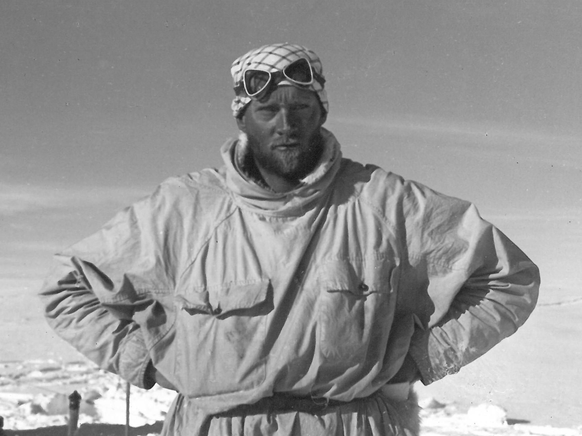
In 1930-31 the London to USA air route was forming, and mapping knowledge of Greenland was required. Hence John Rymill went on a mapping expedition to Greenland. Survival skills were learnt from the local eskimos. Experience with husky sled dog teams was acquired. Whips made in Melbourne by an indigenous man were introduced to Greenland dog sled handlers. John’s surveying skills were quickly recognized, and a Polar medal was awarded.
Antarctica was next, and he was able to assemble funding equivalent to $3m current for a mapping expedition. His team included four colleagues who had been at Greenland with him and who also had been awarded Polar medals. All five were to eventually earn a second medal for Antarctica. Three year’s supplies had to be gathered for the team in UK.
Individuals were responsible for their own personal effects.
They set sail from UK January 1935 for Antarctica on the RY ‘Penola’ a 30m wooden ship.
Average age of the team was 27. Original photos and film footage were shown. Base camp was established on Argentine Islands near Graham Land. The hut was two stories high on a rocky outcrop. Their single-engine Fox Moth plane was stored at ground level out of winds that could reach up 210km/hr. Living quarters were on the second floor. Oil was drained from the plane after each use to prevent it freezing. The men lived comfortably in extreme conditions. A 3,300m mountain range meant that travel had to be on treacherous sea ice.
Plane landings and dog sled tracks had to be selected carefully. Heavy radios were taken because time signals were required for accurate surveying (within 3 seconds accuracy achieved). Skills learnt from the Canadian Indians and Eskimos meant that the men could stay warm, dry and wear dry clothes each day.
In January 1936, the expedition made their southern base on Debenham island. King George 6 th Sound was mapped. Alexander Land was found to be an Island. Mt Wakefield was recorded as 3117m high. The final effort was when Bingham and Rymill trekked 900km east on a 72-day surveying expedition.
“On their long trips they would do a running survey for maybe 80km and then they would pause for a day to get good sun or star sights to know exactly where they were and then off they’d go again and fill in the gap off to the next one. When they came back they had these field surveys that they then collated into a proper map. They really had the thrill of being the first to map that part of the world.” (Peter Rymill)
In his summary John Rymill (jr) showed how different the revised maps created by John Rymill’s team were to the original Watkin’s map. It was an incredible human experience of kindness and heroics to achieve such maps.
John Rymill (1905-1968) was leader of the expedition in Antarctica, where Willfred Hampton (Ham), pilot, clocked 150hrs flying and flew over 22,000km. Alfred Stephenson (Steve), chief surveyor, compiled extremely detailed maps covering over 2,000km of previously unexplored coastline. Edward Bingham (Doc) was expedition doctor and dog master, ensuring the team and their huskies were capable of sledging over 13,000km.
Robert Ryder (Red), sailing master, sailed over 43,000km, at least half on sail alone (he won a VC in WW2).
These historic achievements need to be publicized, taught and recognized in history.
See “Arctic Pioneer” the book by Peter Rymill.

This article appeared in the Naracoorte Community News.
