Planning for possible future erosion and flooding risks is a hot topic in the Shire of Gingin following public information sessions in Lancelin and Seabird.
The shire’s coastal hazard risk management and adaptation plan (CHRMAP) and coastal management strategy (CMS) and the WA state government’s coastal hazard risk management and adaptation planning guidelines – in particular appendix 4, which deals with planned or managed retreats – do appear to be at odds with each other.
For example the shire’s CMS when outlining management actions for seven sites in Lancelin, Ledge Point, Seabird and Guilderton – without defining the word trigger – refers to trigger-based relocation of coastal paths and trigger-based relocation of coastal assets and infrastructure away from the hazard zone.
Whereas when the Department of Planning, Lands and Heritage and Western Australian Planning Commission’s coastal hazard risk management and adaptation planning guidelines appendix 4 planned or managed retreat – existing planning framework and instruments refers to triggers it provides three examples and also says a planned or managed retreat allows development or structures to remain and be safely used until the coastal hazard risk becomes unacceptable.
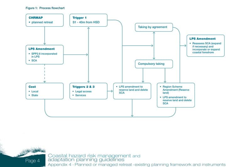
Appendix 4 says initiation of the process to remove at risk development or structures will occur by triggers such as:
- Trigger 1. Where the most landward part of the horizontal shoreline datum (HSD) is within 40m of the most seaward part of a development and/or structure(s) lot boundary.
- Trigger 2. Where a public road is no longer available or able to provide legal access to the property.
- Trigger 3. When water, sewerage or electricity to the lot is no longer available as they have been removed/decommissioned by the relevant authority due to coastal hazards.
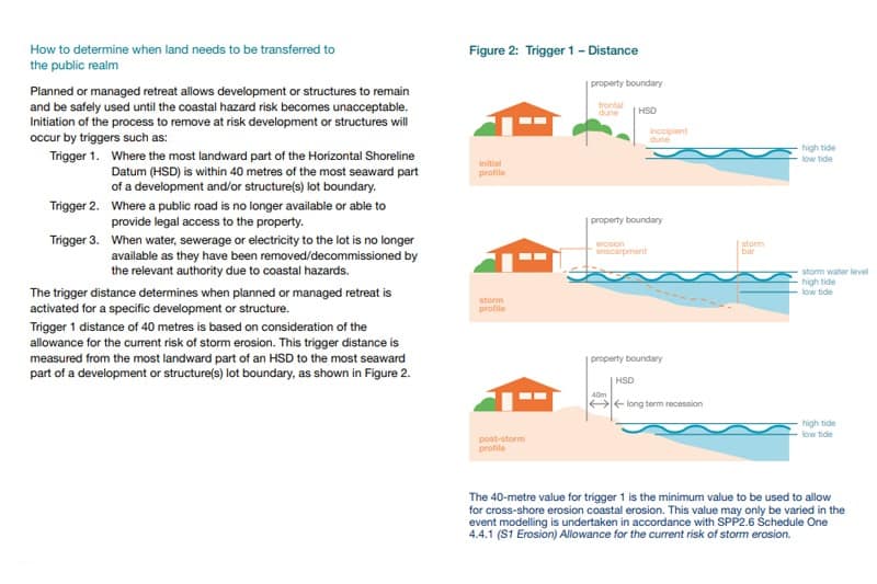
“The trigger distance determines when planned or managed retreat is activated for a specific development or structure,’’ the appendix 4 planned or managed retreat document says.
“(A) trigger 1 distance of 40m is based on consideration of the allowance for the current risk of storm erosion.
“This trigger distance is measured from the most landward part of an HSD to the most seaward part of a development or structure(s) lot boundary, as shown in the illustration below.’’
Initiation of the process to remove at risk development or structures will occur by triggers, according to the state government’s Coastal hazard risk management and adaptation planning guidelines.
In relation to private properties the shire’s documents say the issue is complex, but the short answer is private owners are responsible for the management of their properties.
“There is no legal obligation on the state or local governments to protect private assets within coastal hazard areas, or to compensate for any losses incurred due to coastal hazards,’’ the shire documents say.
“Should damaged assets pose a risk to public safety, removal may be required.
“State or local government are also not obliged to protect public assets, although they would need to ensure public safety and so might need to remove assets that would be of danger to the community, if maintaining the asset is not an option.’’
Meanwhile, the introduction to coastal hazard risk management and adaptation planning guidelines appendix 4 says there are private assets along the WA coastline that are vulnerable to coastal hazards.
“These hazards and the associated risks to private assets, are likely to intensify over time,’’ the appendix 4 planned or managed retreat document says.
“It is important to recognise this problem and that the adaptation option of ’planned or managed retreat’ is often the most efficient, effective and equitable response to such hazards.
“Examples or model integrated government programs for coordinated planned or managed retreat of private property do not currently exist locally or nationally for coastal decision-makers to follow or implement.
“Notwithstanding this, coastal decision-makers will need to be proactive in coastal planning with regard to planned or managed retreat and its planning and funding pathways.
“This document outlines the existing planning framework and instruments within which planned or managed retreat could be implemented.
“It applies where existing or proposed development is within an existing subdivision or developed area, as it is these locations that are currently, and increasingly vulnerable to coastal hazards, with limited opportunities to introduce less vulnerable forms of use or development through planning control.’’
Removal of ‘at risk’ development is recommended under certain circumstances which should be identified and articulated through a CHRMAP process, according to DPLH and WAPC.
Appendix 4 says the planned or managed retreat approach is based on principles of social, environmental and economic sustainability and adheres to objectives set out in state planning policy 2.6 state coastal planning policy (SPP 2.6) and that the approach adheres to the principles for sustainable land use and development on the coast and adaptive risk management as required by the Planning and Development Act 2005 (PD Act) and SPP 2.6 respectively.
“The approach ensures the ongoing responsible and sustainable management of the coastline for the benefit of the whole community.
“It ensures ongoing provision of a coastal foreshore reserve and beach amenity and continuing and undiminished public access to beaches.
“It is a planning approach which contemplates existing development or land uses being able to continue until the coastal hazard risk becomes unacceptable.’’
The shire’s summary document says it will commence investigations to determine options for appropriate longer-term relocation/town scale retreat for Lancelin.
“This will occur in conjunction with state government agencies, given the significance of the proposal.
“The process will consider nearby or alternative locations that may be suitable for a new town settlement, that might still enjoy the Lancelin environment, and the shire will work closely with the community to progress this option.
“By 2050 the shire will be prepared with appropriately zoned land available for relocation of properties/assets.
“This will remove hazard risk entirely and provide the community with a level of certainty about their coastal lifestyles.’’
On August 23 Shire of Gingin President Wayne Fewster said the shire’s coastal management planning document was due soon to go to the council for adoption and as part of that process the council would be deciding on actions and improvements that the public consultation had raised.
Cr Fewster also raised what he said was the abuse shire staff had been receiving.
“It is obvious that quite a few out there in social media would have no or very little understanding of local government processes,’’ he said.
“Yes, certain staff have appropriate delegated authority to make some decisions and are responsible for preparing reports for council and they are obliged to consider all relevant information and make recommendations to council.’’
But he said in many instances after considering all the information including the comments received during the consultation phase it was the councillors who made any decision not the staff.
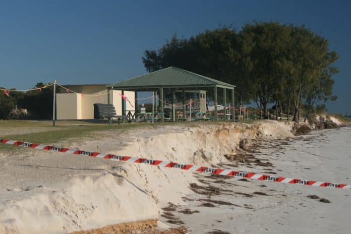
Erosion at Grace Darling Park critical
This article appeared on Yanchep News Online on 28 August 2023.
