
While the number of people living at Portland Roads is small, there is an issue that is divisive among the locals. Does the area need better marine infrastructure? Local resident Greg Westcott has his say on the matter in Cape York Weekly ”¦
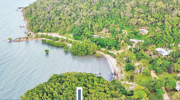
The historic Portland Roads Jetty (circa 1938-1978) still engenders feelings of awe, magnificence, and a degree of romanticism within anyone living at Portland Roads, or for those who are aware of the significant role the jetty played in Cape York’s colonial history.
However, more than 40 years on from the jetty’s demolition, the Portland Roads community is divided by persistent lobbying by a minority of local property owners for the construction of a rock wall and boat ramp that, when completed, will extend out from “the point” about 190 metres into deep water.
This rock wall will need to be at least 4.5 metres high out near the edge of the Fringe Reef.
The proponents of this rock wall and boat ramp are promoting an all-tide access so as to increase Great Barrier Reef-based commercial tourism activity (and the resultant business opportunity for a few).
Unfortunately, to date these supporters have not addressed the adverse impact to the environment and community during the construction phase and on its completion.
The proposed construction necessitates excavating huge volumes of dubious quality rock, granite, and clay base from the escarpment beside the Point, to be then transported, and stabilized as the rock wall out to and beyond the edge of the fringe reef.
The excavation of the hill side for materials, and the simultaneous construction of the rock wall will be an enormous task.
Construction noise and dust will be more than challenging for local residents, while clay siltation leaching out from the rock wall onto the pristine fringe reef would be an ecological disaster.
Our wonderful lifestyle and tourism-based businesses will disappear for the duration of the construction from daily noise pollution, and the necessity for the Point to be cordoned off to boating, tourism, and locals for the duration of the works.
My guesstimate is the works will take one dry season to complete.
Community impact
Even now, Portland Roads is buckling under the impact of visitors launching trailer boats from Portland Roads to access the Great Barrier Reef.
Just recently, in one day there were 28 car/boat trailer combos parked like sardines, literally stopping any other activity along the foreshore.
These numbers of trailer boats are already over the maximum of what this community can handle. Improved roads and an all-tide launching facility will only exacerbate the congestion and chaos that already occurs.
Not least, as impacts go, is the hideous rock/gravel cutting that will blight the Point for a generation to come. Not only will this be an overpowering eyesore, but a reminder to the habitat lost to the cus cus and the palm cockatoo who live in the area.
Further, the height of the cutting will be frighteningly high, will increase the risks of landslides in the wet season, and will dominate what beforehand was our picturesque foreshore and esplanade.
Environmental impact
Again, there has been no discussion from the proponents on the environmental impact of this project if it was to go ahead.
But certainly, several impacts come to mind.
The rock wall by its nature will create an environmental breakwater at right angles to the foreshore, catastrophically endangering the marine environment out to beyond the edge of the fringe reef.
Currents will cease to flow along the foreshore in the bay area in front of the existing properties causing major changes to fish habitat and so affecting the seasonal schools of hardyheads, sardines and the predatory food chain that now abounds.
The wall will also stop the slow natural northern flow of sand around the point into the bay area. What will happen to the sandy beach?
The eastern side of the wall will also retain the snapped off seaweed from strong winds that normally bypasses the point into the bay and further north.
Instead, many tons of seaweed will lay against the wall pungently rotting away several times a year.
We also have to think about the shell life and the beautiful coastal clams now growing on the fringe reef.
Will they get sufficient nutrients once the currents stop flowing on top of the fringe reef, or will it just become a wasteland in what was once paradise?
In summing up; the existing launch facility at the Point for trailer boats combined with the sandy foreshore, and natural sand access at low tide already provides launch facilities for boats up to 8.1 metres on a 1.4-metre tide.
Commercial charter vessels can currently transfer clients from shore to their vessels on a 1.2-metre tide.

Do we really need to have this facility imposed on our community that is unique in its environmental appeal, and a destination that tourists currently acclaim as breathtakingly beautiful?
This article appeared in Cape York Weekly, 23 November 2021.
