Flood modelling advice shows proposed Jane Eliza development is safe and sound
A hydrology report has indicated the proposed Jane Eliza Development will have minimal impact on water levels in the event of future flooding in Renmark and surrounding areas.
Renmark Paringa Council has today released the hydrology report, which showcases a range of modelled situations, including the 186 gigalitres (GL) recorded in the 2022 flood, a higher 250GL event, and the 1956 flood level of 341GL.
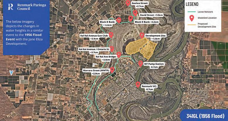
The average water increase across Renmark’s levy network (11 sites for measurement) for a 186GL event, is 2.3cm.
The increase ranges from 2.7cm, to 5.8cm, in a 341GL event, which equates to less than the size of a AA battery.
Council engaged Tonkin Engineering and Neilly Group to produce the flow modelling data as part of the Code Amendment stage of the Jane Eliza Development.
Renmark Paringa Council Mayor Peter Hunter said the hydrology report shows the Jane Eliza Development will not endanger the township.
“Council has received questions from community members about what the proposed development will mean for the town of Renmark in the event of a high river,” he said.
“These questions are valid off the back of the recent 2022 flood, and we have taken these enquiries seriously.
“Council is committed to continuing to communicate the upcoming stages of the project and acknowledges that building trust and understanding around this exciting development is important.”
A preliminary model was conducted as part of the hydrology report, however subsequent reports were required to account for council’s response to a variety of flood events.
The current report is reflective of the conditions that will be in place in the event of future flooding events.
A Neilly Group spokesperson said due to the Jane Eliza Development site taking up such a small amount of the overall floodplain the “overall effects of the proposed development are minimal”.
“The volume of water displaced in the 341GL/day event represents about 2.5 per cent of the total floodplain volume in the Renmark vicinity alone, without even considering the massive flood plains to the north and the south of the township,” the spokesperson said.
“Even replicating the largest flood event on record the effects due to the development are predicted to be less than 5.8cm.
“The effects of the development are essentially limited to the Jane Eliza floodplain, with areas beyond the extent of the floodplain typically limited to 3cm, even under the same conditions as the largest event of record.”
Mr Hunter said while the hydrology findings are a significant component of the process, it forms a small section of everything that needs to be accounted for before the development moves towards a starting point.
“We reiterate that this is a long process and a project that will take many years to come to fruition,” he said.
Developer Wel.Co is currently progressing the Code Amendment for the site, which will include formal public consultation in line with South Australia’s Community Engagement Charter.
The hydrology findings will form part of the technical requirements for the amendment, which seeks to support future development of the area.
The concept plans will evolve as further planning and investigations continue, with detailed designs to follow at the Land Division Consent stage.
Key stakeholders that will be consulted throughout the code amendment phase include the Department for Infrastructure and Transport, Country Fire Service, Department for Environment and Water, Department for Education, the SA Housing Authority’s Affordable Housing Unit, the Environment Protection Authority, the Insurance Council of Australia, and utility providers including SA Power Networks, SA Water, ElectraNet, APA Group, and NBN Co.
For maps of the modelled flood levels, the full report, frequently asked questions and more information about the project visit the website (www.engagement.renmarkparinga.sa.gov.au/jane-eliza-development).

This article appeared in Murray Pioneer, 10 September 2025.