
This article relates to the ongoing debate on ARR.News: Open for Debate – Bushfires, Logging, Burns & Forest Management
Frank Batini
A very large wildfire in the Perth hills catchments in January 2005 had the potential for severe consequences on water quality in domestic water supply reservoirs. Streams and pools were filled with silt significantly impairing aquatic fauna. As these are low-energy streams, the silt will remain for years. Many habitat and commercial trees were killed and many more were damaged. The terrestrial ecosystem after the wildfire was more simplistic and less diverse. After 18 months, the forest, understorey and terrestrial ecosystem were beginning to recover, but full recovery will take some decades. This large fire was eventually contained when it reached areas that had been prescribed burnt and carried low fuels.
Post the 2019-2020 wildfires some fire chiefs and academics questioned the value of prescribed burning. This is nonsense, as it failed to consider scale. NSW and Victoria have only achieved annual targets of <two per cent of the forest area. This means that only ten per cent carries low fuels (less than five years old). In Western Australia the annual target is ten per cent and at any one time, half the forest has low fuel. At 20 tons/ha the fire intensity is 100 times that at two tons, giving firefighters a better (and safer) opportunity for control.
The 2005 fire and its effects
In January 2005 a bushfire in the Perth hills area burnt approximately 27700 hectares on three water supply catchments (Mundaring, Canning and Victoria). An arsonist lit several fires in steep country and under windy conditions. Despite early suppression efforts, several fires coalesced into a wind-driven inferno that headed west towards nearby suburbs. Perth residents awoke to a dense smoke haze that lasted for several days.
Suppression efforts continued for over a week and involved over 700 firefighters as well as aerial drops. Fortunately no lives were lost and no houses were burnt, though damage to sheds and orchards occurred and some firefighters were injured. Strategic prescribed burns carried out 1-3 years earlier eventually allowed control.
In the Mundaring Catchment, large areas were burnt by very high intensity fire. As Mundaring is the main water source to the Goldfield and Agricultural Region, the impacts were of critical concern. Well planned remedial action was required and needed to be in place before the coming winter rains. These included:
- field survey of the fire area to identify and rank potential problems;
- development and implementation of a water quality monitoring program;
- implementation of erosion and sediment control measures;
- a review of reservoir operating strategies and preparation of a contingency plan in the event of serious water quality problems; and
- liaising with land managers to direct remediation actions.
Heavy rainfall from late March 2005 resulted in sediment and ash moving downstream within the catchment and a plume developed within the upper part of the reservoir. For each event the plume was assimilated well before the take off point. Erosion control structures within the catchment were able to trap some sediment load.
Luckily, baseline rainfall, water quality and yield data were available for two adjacent sub catchments, Little Darkin (3800 hectares severely affected by the wildfire) and Pickering Brook (prescribed burnt some 12-18 months previously, thus allowing the wildfire to be readily controlled).
Plots were established, and data collected on damage and recovery of the overstorey trees, on understorey density, structure, dominant species, litter, slope and soil as well as terrestrial and aquatic biodiversity; with these results:
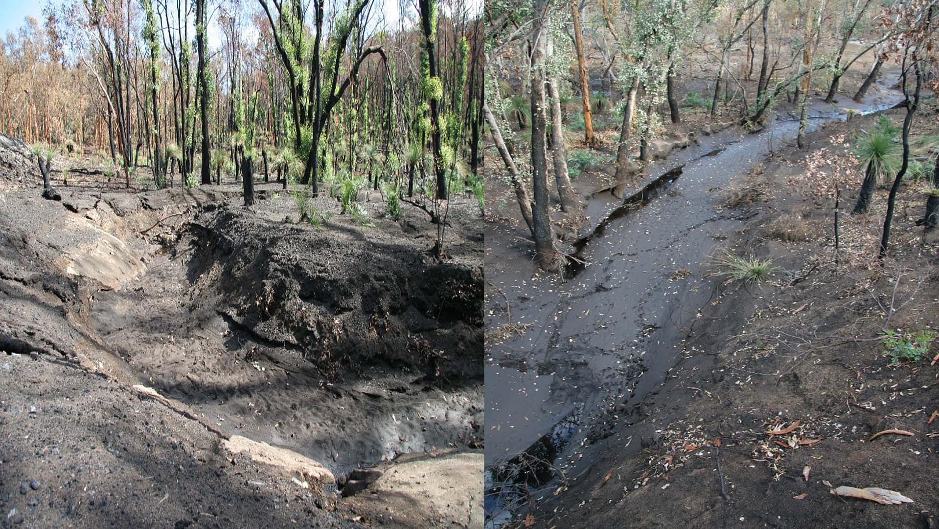
Soils. About 12 per cent of the soil surface in burnt areas was visibly “baked” and altered by the fire, thus allowing for increased watershedding, with 80 per cent of burnt plots showing evidence of surface soil erosion. There was no evidence of surface soil movement in unburnt areas.
Water quality. Following rainfall events in March and April 2005 when about 40 mms and then 60 mm fell on the catchments, very large quantities of soil, silt and ash were deposited within streambeds and pools. Subsequently, in the stilling pond at the Little Darkin v-notch weir, an estimated total of 350 cubic metres of soil and organic matter were removed. By winter 2006, which was very dry, the soils were stabilised by vegetation and much less silt was deposited in the streambed.
Water yield. In the first winter after the fire, the burnt catchment yielded a flow that was 2.2 times that which would be expected based on historical comparisons. This catchment reacted swiftly to rainfall events in the early part of winter when the ground was bare and the soils were water shedding. In the dry winter of 2006, flow in the burnt catchment was only marginally higher.
Aquatic biodiversity. During the 2005 winter, the aquatic biodiversity in the Little Darkin stream was significantly impaired.
Terrestrial invertebrates. Data collected in winter of 2006 show that invertebrates within the wildfire areas were less diverse and contained only a subset of the species found in the area that had been previously prescribed burnt.
Birds and mammals. In contrast to areas that had been prescribed burnt, during the first winter there were no frog calls or birdsong and few mammal tracks were observed in the areas burnt by high intensity fire.
Tree deaths. It is estimated that between 1.5 and 2.3 million trees greater than 10 cms in size were killed in the wildfire. In areas that were fully defoliated about one third of the trees were killed. Many of these were large, habitat trees.
Recovery. Some 18 months after the fire, the understorey density had recovered to levels observed in control plots. Density of tree crowns had recovered well in areas that were scorched. Defoliated areas showed epicormic growth but tree canopies are still below levels in the controls.
Frank Batini is a Forester, Environmental Scientist and Consultant in Natural Resource Management. In 2005, Frank was employed as a Consultant to the Water Corporation of Western Australia. Data on flow, terrestrial and aquatic biodiversity were collected respectively by Water Corporation, University of WA and Department of Environment and Conservation.
