Hugh Schuitemaker, Murray Pioneer
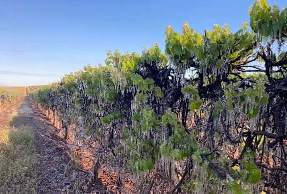
A State Government plan to utilise satellite imagery in assessing frost damage to Riverland grape vines has “missed the mark” for growers needing support, according to senior local politicians.
The State Government last week announced satellite imagery would be used to map the extent of frost damage recently caused to vineyards across the region.
However, Chaffey MP Tim Whetstone said local industry representatives had completed satellite imagery of frost-damaged areas.
“The satellite imagery has already been undertaken,” Mr Whetstone said.
“Riverland Wine have engaged a service provider to do the imagery”¦ (so) I’m perplexed as to why the government are needing to go further afield for that imagery.
“The industry has shown good leadership by immediately going out there, and any imagery today – three or four weeks from the frost event – will be a false reading.
“All the vines have reshot, they are going again, but in most instances they will be fruitless.” The Advertiser – in a story dated 29 September – reported Riverland Wine grape grower chair Ash Ratcliff said “satellite images taken pre and post frost show 52 per cent, or half of all blocks in the Riverland, are frost-affected”.
Mr Whetstone said needing to capture further images would delay crucial support for growers.
“The (State) Government has missed the mark here”¦ the information is already there and that information is credible,” he said.
“It was presented to a growers’ meeting a few weeks ago, and I see that as credible evidence of what the impacts of the frost have meant to the region.
“It’s just delaying the inevitable”¦ the frost damage is very visible on the imagery.
“We’re going through a tough time at the moment. The government keeps putting hurdles up and I don’t think it’s of benefit at all.”
Barker MP Tony Pasin said direct financial support was needed for growers heading into the next vintage.
“Satellite imagery to map the extent of frost damage across SA may assist some growers and the local sector more generally with future planning and risk mitigation, but it’s not offering growers impacted by the most recent frost event any relief as they stare down the barrel of reduced volume this vintage,” Mr Pasin said.
“Minister (for Primary Industries and Regional Development Clare) Scriven’s announcement sounds more like a deflection coming from a government who has refused to support primary producers through one of the most significant shifts in market conditions in decades and is running away from declaring much-needed support for frost-impacted growers.
“When will Labor start listening to our primary producers about what they need to navigate through commodity shocks and severe weather events?”
However, Ms Scriven said information from the mapping would allow grape growers to consider “frost minimisation strategies around vineyard floor management, pruning method and timing, trellis height, variety choice and investment in wind machines or sprinklers”.
“We know that frost damage has been widely reported across our wine regions and that this is a very stressful time for many producers,” Ms Scriven said.
“We encourage producers to explore the support available, which the State Government has invested heavily in over the past 12 months.
“The satellite mapping will assist us to conduct a thorough state-wide assessment with an initial snapshot of the extent of frost damage on grapevines expected to be available next month.
“The satellite mapping is an innovative tool that will significantly help grape growers with their future planning and decision making.”
SA Wine Industry Association chief executive Inca Lee said “these maps will provide an additional tool for growers to support future vineyard management decisions”.
This article appeared in the Murray Pioneer, 16 October 2024.
Related stories: Calls for frost support, Frost and lost, Grape growers preparing for ‘devastating’ frost damage
